Having come another 160 miles from Damascus, I'm now approaching the middle of VA and have started to get a taste of what it has to offer. Unfortunately, it offer puds. Lots of them. Up and over the viewless Brushy Mt. 4 times in 2 days? Sure, sounds lovely!! Its begining to become a little more obvious why many people drop out here; with the warm weather comes more leaves and the onset of the notorious "long green tunnel" effect. Don't get me wrong, its a lovely place to walk in for a day or two, with quaint fields and pastures, great rivers, old farms, tons of flowers and the accompanying scents and colors... buts its hard to keep pushing during the day when every aspect of the scenery begs for a Hucklberry Finn-style nap with a straw hat pulled low over the eyes.
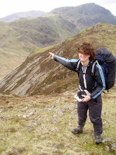
Luckily it hasn't all been so mellow, as the ascent of Mt Rogers and the Grayson Highlands afterwards were both awsome. Open upland meadows, half wild ponies and 70 mph gusts of wind tend to keep things interesting, as do ankle murdering rocks. Dismal Creek Falls was fun and accompanied by some welcome trail magic in the form of some vacationing Virginia Tech. students who brought and shared some bbq, as was the unexpected hitch into the town of Bland. Yes, a town called Bland. Luckily the company was good and the hitch back to the trail was fast, so it didn't sidetrack things too much. Nice views from the aptly named Angel's Rest down to Pearisburg where enough to whet my appatite for civilization to the point that I overshot the turnoff into town and had to hike several miles back, but it was all worth it for the resupply and a pint of ice cream.
I'm still making good time despite some earlier ankle pain which seems to have largley resolved itself, so now its just a simple 340 mile jaunt out of VA. Front Royal,VA, (zip code 22630) is my next big stopping destination, where word has it my sis has secured a sweet pad from one of her coworkers at the zoo; I'm reserving the shower in advance. Their animal rehabilitation park is out near the trail, and its should be one of the cooler sights on the trail through this state, so I'm definitely looking foward to it. After that is Harper's Ferry, WV, (zip code 25425), the spiritual half way point of the trail, and the point where the terrain and place names start getting a little more familiar. DC, NYC and CT get closer with each step, so remaining motivated isn't a problem. I'll be seeing everyone soon, but due to the awfull cell phone reception in VA so far, I can't promise how in touch I'll be. Regardless, messages are always welcome, and I hope everything is well in the real world. Talk to you all later.
Tuesday, May 27, 2008
Backlogged stuff
A few more vocab words before I start.
Hiker midnight - any time after dark (usually around 9:00), when everyone starts passing out
Hiker cologne - Smoke from the fire. Because lets face it, anything smells better than a hiker at the end of the day
P.u.d. - Pointless up-and-down. Any ascent that yields no worthwhile views, no shelters, no water, and is generally monotonous. VA seems to specialize in these.
AT -Shorthand for the Appalachian trail, obviously
2,000 miler - anyone who has completed the whole AT, regardless if it was in one year or over many
PCT - Shorthand for the Pacific Crest Trail, a 2,600 mile trail in California, Oregon and Washington. Higher elevations, less water and more drastic weather make it more logistically difficult than the AT, but an easier trail grade and less rocks and roots makes it less physically demanding.
CDT - Shorthand for the Continental Divide Trail that follows the Rockies for the most part, also from Mexico to Canada. At 3,100 miles, it is the longest, hardest, and least traveled of the long trails in the US.
Triple Crown - Title awarded amongst hikers to someone who has thru-hiked the AT, the PCT, and the CDT
Hi everyone, writing to you from the library in Pearisburg, VA. Seeing as I never got to update after the end of Trail Days in Damascus, I'll just give a quick recap of some of the... more colorful moments.
-The hiker parade, where everyone arms themselves with water ballons and squirt guns and its an all out war of hikers vs. townies
-huge bonfires every night at multiple camps, each with their own flavor; some drum music, some bluegrass, some storytelling, etc.
-An impromptu list of a typical days fluid consumption; beer, bloody mary, beer, margarita, beer, vodka lemonade, beer, beer, water. Its just the most available drink, what can I say.
-Hilarious D-list horror movies about a killer grizzly bear. Best movie special effects ever (and yes, they are fake)
-Inspiring (if somewhat cheesy) movies about the CDT. Triple crown here I come!!
-Hiker talent shows, the useless gear competition, eating contests, free home cooked meals, and all the drool worthy gear you could lays your eyes on.
-Lazy days by the river and lazy nights under the stars till 4 a.m., hiker midnight be damned
Friday, May 16, 2008
Lazy Days
If anyone doubts the relativity of time, they should become a hiker. On the way into Damascus, Mike and I hiked 26 miles before 3:45, an impressive feat. Now, at Trail Days, time seems to go so slowly (a good thing out here), and hours can be spent just chilling around the fire, meeting new people and seeing old ones. We've all been taking advantage of the free events in town; food, movies, talks and impromptu parties seem to be the norm every day, and the festival has barely even started. The weather has bee a little crappy, but rain and wind does little to dampen the spirits of thousands of hikers, especially when copious amounts of beer are involved. Without too much to do or write about, I thought I'd start a little glossary of trail terms for everyones amusement. Feel free to skip ahead if this is stupid.
"white-blazing"--a hiker committed to hiking 2,100+ miles of trail along the official route, which is marked with white blazes. I'm one myself, and while I don't consider myself a purist or anything, it just seem to be the most authentic way to do things.
"blue-blazing"-- taking side trails off the official route marked with blue blazes. While there are numerous loops that add milage in order to incorporate somenatural feature, this term is usually reserved for someone who takes a shortcut (such as at Standing Indian Mt in GA, where nearly 12 miles of tough climbing can be circumvented)
"yellow-blazing"-- hitch hiking past parts of the trail, so called because of the yellow traffic lines. Generally looked down upon by white-blazers unless there is an special circumstance. Often reserved for the people that choose to hitch to popular hostels or shelters to party; see also, "lazy jerks"
"slack-packing"-- Hiking for a day with only a small daypack with food and water. Usually arranged though a hostel with a shuttle service or friends with cars, the hiker is dropped off a days walk away from the hostel, from where they walk backwards towards it and are shuttled ahead again the next days with their full pack. Easier for older or sick people, though many are of the mentality that if you can walk 400 miles with a pack, another 15 isn't going to kill you.
"Camel up"-- Chugging a liter of water at a good source, then refilling your canteen so as to stay hydrated.
"Piped spring"-- The best kind of water source, where a pipe is driven straight into a spring and clear water comes out. Doesn't require any filteration or purification, except for the exceptionally neurotic.
Thats all I have time for now, will probably write again tomorrow just to kill some time, sorry the posts haven't been too interesting but with limited time I wouldn't even being to describe stuff in detail. Talk to you later.
Thursday, May 15, 2008
The road to Damascus
I'm posting this from the library here in Damascus, VA, the site of the massive Trail Days celebration which officially starts this weekend. Its pretty exciting being here, having passed into my 4th state on the trail and reaching the first big milestone; at 470 miles in, this is essentially the quarter mark. The road here from Erwin, TN, has been interesting with several waterfalls, lots of good people and some strange situations.
Its taken awhile, but everyone seems to have found their pace at the moment and as a result some groups have formed up. There are quite a few people who I've been traveling with lately, as we've all been keeping the same pace to get here in time for the festivities. Bad Dinner, Geoff, Wookie, Wasabi, Mike, Matchstick, Red Eyes... and many others that I hope to see more of as things progress here. After the festival however, it seems like everyone is going to scatter, and there will be many new faces on the trail as well, so we'll see how that goes.
Highlights for this section have been some great riverwalks, including one down a small rock gorge with overhanging rhododendron trees, several balds with nice views, an awsome shelter in a convertaed barn at the head of a long valley, and a challenging hike to the top of Roan Mt. in the wind and fog. The trees are getting their leaves, and the "long green tunnel" is beginning to emerge, yet another milestone to tally up. Unfortunately, time on the computers is limited and I have to go, but hopefully I'll have the opportunity to post again before I leave here and keep everyone updated on the goings on in town. Talk to you later.
Wednesday, May 7, 2008
Controlled Burn
I'm writing to you from Uncle Johnny's Hostel outside Erwin Tenessee. Its a nice place right on the banks of the Nolichucky River and just a few yard from the trail which is always a plus. The hike here from Hot Springs has had its highs and lows, with a couple of nice balds and lots of flowering trees, but also some bland sections. The most unnerving part however was the last few miles here; the forest service has been conducting controlled burns that left everything around the trail burnt and smoldering in places, resulting in a black and brown landscape with a lingering smoke smell. Cool, but unexpected.
I seem to have found a group to hike with, or at least a loose affiliation of guys. Bad Dinner and Geoff, who I met at Fontana Dam, have been playing catch up with me and we've bumped into each other alot. Wookie and Wasabi, two guys from Maine, have also been going about my pace for now; we'll probably all stick together a bit until Damascus. My trail name by the way is Sandman, on account of the fact that I use sand in my sculptures, though it can also be "Sandblaster" or "Sandstorm", depending on how fast I blow by people. I still keep a quick pace, but with the Trail Days party in VA starting in 8 days, I've had to slow down to make sure I don't pass it by. Once that's over, the real fun will begin; I'm eager to see just how far I can push my body, and once the restrictions are off I plan on putting out some real monster days and catching up with people down the trail. I might try my feet at some night hiking as well, just to add some variety. Only time will tell, and seeing as my gear and myself seem to be holding up fine it'll be interesting to test my stamina a bit. As always, thanks for reading, feel free to shoot me questions or anything, I'll probably update again in Hampton TN or Damascus.
I seem to have found a group to hike with, or at least a loose affiliation of guys. Bad Dinner and Geoff, who I met at Fontana Dam, have been playing catch up with me and we've bumped into each other alot. Wookie and Wasabi, two guys from Maine, have also been going about my pace for now; we'll probably all stick together a bit until Damascus. My trail name by the way is Sandman, on account of the fact that I use sand in my sculptures, though it can also be "Sandblaster" or "Sandstorm", depending on how fast I blow by people. I still keep a quick pace, but with the Trail Days party in VA starting in 8 days, I've had to slow down to make sure I don't pass it by. Once that's over, the real fun will begin; I'm eager to see just how far I can push my body, and once the restrictions are off I plan on putting out some real monster days and catching up with people down the trail. I might try my feet at some night hiking as well, just to add some variety. Only time will tell, and seeing as my gear and myself seem to be holding up fine it'll be interesting to test my stamina a bit. As always, thanks for reading, feel free to shoot me questions or anything, I'll probably update again in Hampton TN or Damascus.
Friday, May 2, 2008
Conquering the Smokies
I must say, seeing the Smokies in the rain and fog has to be my favorite experience so far. Upon waking up the day after the big rain, there was...more rain, at least for a time. It gradually tapered off as the morning progressed, but then the fog drew in. It was essentially one squishy step after another all day, but once the damage is done, you might as well roll with it. Besides, having wet boots just gives you more of an excuse to splash through every 4 inch deep puddle you can find. It was the day when everyones footwear sacrificed its individual character and became a uniform brown. It was also the day of Clingman's Dome, the highest altitude peak on the whole trail, complete with a concrete tower with such expensive views that you could almost see the tops of the trees 20 feet away. Its really quite haunting, particularly when many of said trees are dying due to invasive insects; it could have been the setting of a Stephen King novel.
The trail became darker and more densely forested as the altitude got lower, and the feeling of being enveloped by a single living being was palpable. Everything in the immediate vicinity was green and dripping but quickly receded into brown, gray and black shadows in the distance. Often the trail had become a watercourse, and the light reflecting off the stream would look like a silver thread in the gloom. Charle's Bunion, a stone outcropping that jutted away from the forest, was even more impressive in the clouds; sitting on the rocks, all one could see was pure white, an experience the eyes aren't exactly used to. Had the weather been clear, I'm sure it would have been a great view. But after a while, all the vistas look the same, and this was an entirely unique experience. Being able to hear the wind, feel the clouds moving by, and taste the wettness was surreal.
Unfortunately, I had been warned by a Ridge Runner (a volunteer for the Appalachian Trail Association) that the temperature would be dropping, and I had many miles to the next shelter. It was along day (23 miles), but luckily the site I was aiming for had spots in the lean-to. The place was beyond crowed, but with the thermometer hovering in the low 20s, the extra heat was appreciated. Even a campfire could not keep my waterlogged boots from freezing the next morning however. It was with cold clothing and frozen limbs I hurried out and got on my way. The first mile was torture, but once my internal furnace got going and I thawed out things became more bearable. While it wasn't snowing, there was a good inch on the ground and ice everywhere. I pushed all day, striving to get to lower altitude and was not disappointed when I could finally go about camp with all my winter gear on. All told I went from freezing, frost covered trees to green sprouts and sunlight in one day. I decided to stop short of Davenport Gap, the official eastern boundary of the Smokies, and ultimately had an entire shelter to myself as most hikers decided to go on to a nearby hostel.
Having had 2 hard days in a row, I decided to take it a little easier in the warming weather. Upon leaving the park the trail changed drastically, becoming more reminiscent of England with green meadows and small streams. The highlight was Max Patch, a high bald with short grass and great views of the mountains we had just left. I stayed at the Roaring Fork Shelter, which, according to the trail register, had been visited by a bear several nights in a row. The other hikers and I built a fire hoping to keep it away, and fortunately we were not visited, though apparently he hit the next place down the trail. From there it was a very easy 18 mile hike here to Hot Springs which some friends and I traversed in record time, arriving here before 3 pm. I got a room at the Sunnybank Hostel, a great place in beautiful, cluttered old Victorian house where I could take a "zero day", and not hike at all in order to reccuperate from the Smokies. The next convenient resupply for those of you keeping track will be in Damascus, VA, the site of the famed Trail Days celebration. Its a few hundred miles away, but it should be easy going and I plan on taking a day there. The zip code is 24236, see the earlier posts for more info on how to label any packages. Sorry for the length of these, but alot has happened in the last week or so, what can I say. Hope to hear from eveyone, I'll be thinking of you all.
Quick Updates
Hi guys, sorry for the delay in posting, but I've been in the Great Smoky Mountains for the past few days and obviously internet is not readily available. I'm writing this from the Hots Springs, N.C. outdoor store and I only have limited time, so I'll go in parts.
Fontana Dam was the last major area I stopped in about a weak ago. As the name suggests there is a dam on the Little Tenessee River with an adjoining resort village that offers some resupply, and I was supposed to recieve a mail drop with food for the Smokies there, but alas it was several days late. Fortunately I had some food left so I hit up the grocery there, got restocked to get through the mountains, told the post office to foward my package here to Hot Springs. The shelter at Fonatna is know as the "Hilton" because its relatively large (holds 24 people), has lots of floorspace, a nearby bathroom with free hot showers, a water fountain and spigot, and a shuttle to the resort. The place was pretty full with lots of fun characters so a good time was had by all, and included some trail magic in the form of free pizza and beer. There were encroaching clouds in the morning but I decided to get an early start on account of the massive climb out of the dam. It started pouring about as soon as I set foot across the river, but I was pretty well covered and the rain soon subsided. The day was mostly uphill into the park and ended in Spence Field Shelter, an clean, quite place up on a high field with nice views of the mountains. The sunset was awsome with purple clouds fading against the hills past the straw covered field speckled with trees and wildflowers.
The next day's forecast was for rain in the afternoon so I headed out with some raingear on. Saw some wild turkey and boar early on, but things soured a bit when it started pouring once again before I could get rain pants on, resulting in soaked boots (they have yet to fully dry out, still). I stayed in the Silers Bald Shelter, and it quickly filled up with hikers straggling in from the rain. Some people from the Fontana shelter joined, as well as some days hikers and we all decided to end the day early and wait out the rain, which proceded all night and filled the shelter with staccato beat from the tin roof.
Subscribe to:
Posts (Atom)