Thursday, August 26, 2010
And Finally, the Photos
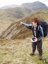
Finally, finally got around to getting the pics off my camera and putting them on Photobucket.com. The account name should be spibop15 if anyone wants to take a gander at my awful photography skills. They still need to be edited, touched up, and organized which, knowing myself, will be accomplished sometime around 2020. But its a start anyway.
The End of Days
Hi everyone, I'm writing today from my cousin Megan's house in Seattle, having truly finished my thru-hike nearly a week ago.
Ed, Straight Jacket and I left Skykomish together, getting a lucky hitch from a hiker girl passing through the area. Given that it was only a few days up to Stehekin, we ended up sticking together for the most part as the trail made its way into Glacier Peak Wilderness. This really was one of my favorite sections on the entire trail; perhaps there is some bias due to the fact that it is so near the end, but the views were awesome and just kept getting better. There was a minor scare when a forest fire started over a nearby ridge, but fortunately it never got close enough for us to see. For a night the air got thicker and the sunset darker, but the burn stayed out of sight and must have died down relatively quickly.
While we did manage to avoid one catastrophy, signs of older cataclysms were evident all throughout this section. In 2003 and 2005, fires, avalanches and mudslides brought on by storms ruined the 50 or so miles of trail to the west of Glacier Peak. As a result, the Forest Service officially closed the trail there and created an inferior detour around the east side of the mountain. For several years the original trail was unmaintained and impassable, but that didn't stop thru-hikers from trying anyway. In recent years there has been a huge effort to reconstruct the path, and fortunately it was largely finished by the time we arrived. We passed several trail crews who had been blasting new tread and cutting out blowdowns, apparently over 100 at last count. Some areas were still completely overgrown with brush however, and the general difficulty of the section made it slow, if beautiful, hiking for a few days. The views of Glacier Peak from Red's Pass were astounding, with rocky, ice carved valleys giving way to meadows of wildflowers and shadowed forests punctuated by fast running creeks. Eventually Ed, Straight Jacket and I made it to High Bridge Ranger Station and the road to Stehekin after hiking an exhausting 30 miles nonstop in order to catch the shuttle into town.
Our arrival at the town was somewhat awkward however. We, being the first straight-through hikers of the season for several thousand miles, had become accustomed to being greeted by south bounders, day hikers and people in town as such. Unfortunately, several yellow-blazers (i.e. hitchhikers) had skipped around us and were claiming to be the head of the pack, gloating to the locals while leaving out the fact that they had access to a car. As we arrived at the ranger station, these 4 were on their way out, basically putting them a full day ahead of us. I, not really giving a damn about the status of a few lazy hitchers, decided to head into Stehekin for the night, seeing as everyone raves about how great the town is. Ed and Straight Jacket opted to simply resupply at the local bakery and head out immediately in order to beat the pretenders to the border, thereby missing a great town stop and a chance to relax before hitting the terminus. I said goodbye, and had to see their tracks ahead of me for the last 80 miles (ironically, I still beat the others to Canada somehow. I think they took one more town stop at highway 20). Stehekin was beautiful, and I'm glad I stayed; less a town than a resort, it sits on the end of Lake Chelan and is inaccessible except by boat, seaplane, or boot. The nearest town is a 4 hour boat ride down the 50 mile lake, which is one of the deepest in the U.S. and boast sheer cliffs that drop straight down to the water. The food was excellent, the locals and tourists were friendly, and hitting the bakery in the morning gave me the best resupply I could hope for for my last few days.
Upon leaving town, alone this time, I immediately ran into a few black bears. Normally, this would be no cause for alarm, but given that I was laden with freshly baked treats, I was a little more wary than usual. Fortunately there was a large group of horse riders heading up the trail as well, so I wasn't too worried. I even had the chance to race them for a good 20 miles as they too were heading up the PCT; it was a close call, with them having to take frequent breaks as I simply busted up the trail, but sadly the hare won this time. They passed me just minutes before hitting their trailhead at Rainy Pass.
From this point on, I was in a strange situation. My mom and sister were due to arrive several days after I left Stehekin and were planning on picking me up at Rainy Pass... a full 60 miles south of the terminus. This meant I had to hike up to the border, then turn around and come back. For a thru-hiker, backtracking is practically unheard of; we typically shun it to a comical degree, to the point where heading 20 feet back down the trail is a cardinal sin. In that light, 60 miles is blasphemy. Thankfully, the last section was some of the most stunning yet encountered, so the bitter reality of the trek back was lessened somewhat. To be truthful, I was looking forward to being able to relax and have a leisurely hike back with the chance to run into some old friends. The North Cascades are great, and I was lucky to have some superb weather on my last stretch. The area is a full of granite spires and crags, green valleys, dense woods, and distant, snow covered peaks wreathed in clouds. With alot of side routes providing access to the PCT, the trail was somewhat crowded at times, but the day hikers were friendly and the company was welcome.
Despite the plethora of trail folk in the area, I was still surprised to find several other people at the border monument while I was there. It is a rather unimpressive thing, and aside from the fact that there is a giant clear cut creating a 20 foot wide swath through the forest, there seems to be little reason to take a day hike out to see it. None-the-less, I was accompanied by 4 others when I reached the terminus, a huge achievement accomplished. Due to my situation however, I felt more simple satisfaction than pure elation; I still had another 60 miles of rather strenuous hiking to do. After a celebration feast of a cinnamon roll (hiked out from the Stehekin bakery) and blackberry brandy, I turned around and started the trek back south. Given that I had plenty of time before my pickup date, I tried to take it easy, ramping down my mileage each day. Going from 40 to 35, then 30, 25, 15 and finally a laughable 5 miles a day felt like luxury in the perfect weather which, ironically, only turned slightly sour on the last day. Without cell service, and not having talked to my mom or sister in a week, I was somewhat worried that there would be some sort of hang up and I would be left sitting at the trailhead for hours in the rain, but mercifully they arrived exactly on time.
Well. That's about it for now. Much has happened since then, I've probably droned on long enough, so I'll get to that later, along with the photos. The flight home is tomorrow and soon I'll find myself with oodles of time and no daily ritual to space it with, so who knows where to go from here? Already the thoughts of the Continental Divide Trail have started, but that is far in the indeterminate future for me. I'm still waiting for the reality of the fact that I'm done hiking to hit me. For now, sleep. Or waking. Who knows.
Tuesday, August 24, 2010
The Daily Ritual
Wake up at 4:30 or so, just as the stars begin to wink out overhead. Dawn is still far away, but its time to get the day moving, especially as I seem to take longer than the average thru-hiker to break camp in the morning. If I'm in a leisurely mood, start some water for tea or coffee while still swathed in my sleeping bag, naturally. Otherwise, move right on to a breakfast of a few cups of granola with powdered milk added. While eating, start getting dressed... still in the sleeping bag, natch'. When done, do the dishes, get everything packed and ready to go, then spend a few more warm blissful minutes before getting all my bedding stuffed.
With the tent still up, get the backpack loaded; sleeping bag on the bottom right, with my bag liner next to it and stove on top of that. Next, the two food bags, one with snacks and lunch, the other with breakfasts and dinner, then bunch my long sleeve shirt in the spaces around those. With the maps for the day already in my pocket, any extra guidebook pages and miscellaneous items are stowed in the top pouch. Carefully get the socks on, after bandaging any hot spots or blisters, then get the boots cleaned up and laced. Finally, with everything else done, get out and take down the tent, stuffing it in its bag and wrapping the whole thing in the sleeping pad, then tying the bundle up. Strap the whole deal on top of the pack, get the trekking poles, and head out. The water for the start of the day (the first 20 miles or so) was acquired last night, so no need to stop for awhile.
Hike for about 4 hours or so, or however long you can ignore the hunger building in your stomach, then stop for 10 or 15 minutes to rest, enjoy a view, and possibly clean out the boots again. Another 4 hour stretch ensues; its only 2 or so, and already 25 miles have flown by. Time for another break, this time maybe a bit longer, and to fill up on water. The familiar ache in the feet begins anew after standing up, but luckily it will be largely gone in a few minutes. After 30 miles, the challenge of keeping the momentum going really begins, and the familiar, sometimes hostile discourse between mind and body starts.
Body: I hurt a bunch. Maybe its time to stop soon?
One more rest stop will usually suffice to end the Descartian dialogues, and then its only a few more hours hiking until camp. The tent goes up first, everything is unpacked, and water is procured before starting dinner. Unlike most thru-hikers, I at least entertain the idea of making a campfire, though on a big day that is unlikely to happen; the sun is already well on its way down when dinner is finished, and it can be a race to eat before passing out as it is. After clean up and all, its already pushing 9:30, in other words a little past hiker midnight. There is just enough time to read the guidebook for the next day, then off to bed once everything is organized for the following morning--there is nothing worse than groping around in the half-darkness for breakfast when another long hike lies ahead. So ends a 40+ mile day on the PCT.
With the tent still up, get the backpack loaded; sleeping bag on the bottom right, with my bag liner next to it and stove on top of that. Next, the two food bags, one with snacks and lunch, the other with breakfasts and dinner, then bunch my long sleeve shirt in the spaces around those. With the maps for the day already in my pocket, any extra guidebook pages and miscellaneous items are stowed in the top pouch. Carefully get the socks on, after bandaging any hot spots or blisters, then get the boots cleaned up and laced. Finally, with everything else done, get out and take down the tent, stuffing it in its bag and wrapping the whole thing in the sleeping pad, then tying the bundle up. Strap the whole deal on top of the pack, get the trekking poles, and head out. The water for the start of the day (the first 20 miles or so) was acquired last night, so no need to stop for awhile.
Hike for about 4 hours or so, or however long you can ignore the hunger building in your stomach, then stop for 10 or 15 minutes to rest, enjoy a view, and possibly clean out the boots again. Another 4 hour stretch ensues; its only 2 or so, and already 25 miles have flown by. Time for another break, this time maybe a bit longer, and to fill up on water. The familiar ache in the feet begins anew after standing up, but luckily it will be largely gone in a few minutes. After 30 miles, the challenge of keeping the momentum going really begins, and the familiar, sometimes hostile discourse between mind and body starts.
Body: I hurt a bunch. Maybe its time to stop soon?
Mind: Dude. Its only like 4 p.m. There is crazy daylight left and many miles to go before I sleep. Keep walking, chump.
Body: Really funny, jerk. If thats the case, let me give you a friendly reminder of the fact that I'm tired every time we take a step. Have fun with that.
Mind: Not gonna do any good. You might as well cut it out, we're still hiking for another 10 miles. Hope you like rocks.
Body: I'm calling my union rep...
One more rest stop will usually suffice to end the Descartian dialogues, and then its only a few more hours hiking until camp. The tent goes up first, everything is unpacked, and water is procured before starting dinner. Unlike most thru-hikers, I at least entertain the idea of making a campfire, though on a big day that is unlikely to happen; the sun is already well on its way down when dinner is finished, and it can be a race to eat before passing out as it is. After clean up and all, its already pushing 9:30, in other words a little past hiker midnight. There is just enough time to read the guidebook for the next day, then off to bed once everything is organized for the following morning--there is nothing worse than groping around in the half-darkness for breakfast when another long hike lies ahead. So ends a 40+ mile day on the PCT.
Monday, August 23, 2010
Friday, August 13, 2010
Sky Time
Hi everyone, writing to you from Baring, WA, a scant 181 miles from the Canadian border. The resident trail angels, the Dinsmores, host hikers before they set off on the last little jump to the border and set them up in their sweet guest house. I was hoping to update in Cascade Locks (the last town in OR), but had to bounce out before getting to the library... and now I'm most of the way through the last state. Craziness.
The end of OR was definitely an improvement over the begining. After leaving Bend, the trail goes around glacier covered Mt. Jefferson and Mt. Hood, the latter of which is home to the historic Timberline Lodge and tons of skiers. The entire mountain seems to be made of ashy silt, like a giant sandpile cut through by the snow-fed creeks from above. These create giant canyons in the dust seemingly held together by the thin stips of trees growing on top. Ramona Falls, deep in a wooded gully and flowing down a mossy wall, was a highlight of the area and flooded with photographers. This however paled in comparison to the Eagle Creek trail, a detour that led down from the mountains to the Columbia River Gorge at Cascade Locks. The path is famous for its waterfalls, which tumble from all sides down a narrow basalt canyon. The tread itself is often blasted into the rock, and indeed tunnels behind a 150 foot cascade at one point. Needless to say the trail is popular with day hikers, especially the cliff jumpers who make use of the deeper pools. All in all, its one of the highlights of the entire PCT.
Cascade Locks itself is conveniently located directly on the trail after Eagle Creek, and holds the distinction of being right on the border of a new state. Given how long we were in California, Oregon seemed to fly by. From here the trail crosses the Columbia River on the Bridge of the Gods at an elevation of 180 feet, the lowest point on the entire trip. Unfortunately, WA seems determined to make up for the flatness of OR before it; immediately upon entering the state it takes a roundabout route that climbs more than 5000 feet somewhat needlessly.
Thankfully the state has redeemed itself fom its less than auspicious beginings. Though it tends to be much steeper, and the climbs more frequent, WA has been pretty stunning. The north Cascades are awesome, rugged and rocky below, clothed in glaciers above, and peppered with wildflowers all over. Mornings and evenings are cool and often shrouded in mist, making for good hiking in the eerily silent and still air. The Goat Rocks and Alpine Lakes Wilderness are other areas I would love to revisit, each offering great views, plenty of secluded camping and crystal clear water.
Personally, I view this hike as an oppotunity to scout out places I'd like to spend more time in, not as a relaxing experience itself. Ed, Straight Jacket and I have been at the head of the crowd for awhile now, hiking alone but always in the vicinity of each other. Waking up at 4:30 a.m. and going until after 7 p.m.or so with maybe an hour and a half of rest, we've all been pushing 40+ miles a day. While to some it seems like racing, honestly it is simply hard to put the brakes on ones momentum. Knowing that your legs can go farther in a given day, it almost seems insulting not too, like they are entities of their own. With only 181 miles left to go, I hope to be finished in just 5 or 6 days, then who knows what comes next.
Subscribe to:
Comments (Atom)