I'm writing to you from the Big Bear Lake Hostel in CA, and, crazy as it may seem, I'm already 10% of the way done. I hitched into town from Highway 18 which is at the 265 mile mark, a small feat, but one to note none-the-less. This first stretch has just flown by, and as odd as it may sound it feels like I just started yesterday. Its amazing to think that so many miles could roll by so quickly, especially considering that it has not been easy by any stretch of the imagination. With that, I'll do a little recap since the last (albeit delayed) post.
From Idyllwild I was able to hitch to the neaby town of Anza where I was able to reunite with Axilla, whom I had been leapfrogging with for a few days prior. We both were waiting for a trail Angel named Rockstar from near San Diego who had agreed to give us a ride to the kickoff. It took some time, but eventually we found ourselves back at Lake Morena, a mere 20 miles north of the border. It was strange backtracking to the party, but it gave us a chance to see people we had passed earlier on, and forced us to slow down and allow to snow to melt farther north. The kickoff was pretty fun with lots of free food, several lectures on trail conditions and wildlife, some outfitters to resupply and drool over new gear at, and a chance to preview a new National Geographic Wild Spaces show about the PCT (hiker hint: for those looking for a sweet drinking game, take a sip every time they use a word like "extreme", or whenever they make a new "rule".) Once the festivities ended on Sunday morning, several of us got a ride back to the trailhead near Idyllwild from Rockstar, who, obviously, is awsome beyond compare.
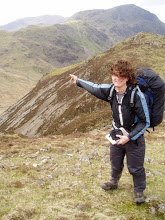
We headed up into the San Jacinto Mountains, the first major hurdle of the hike, and one we had all been dreading due to the late snows. That day included the first rattlesnake sighting, but overall it was a short day easing back into to hiking groove. The view that night was awsome with views back towards the high plateau we had just left, as well as down onto the lights of Palm Springs. The next morning I got an early start in order to hit the expected snows early before it could melt and become soft. The snow can appear suddenly depending on the direction of the slopes and if there is tree cover, so moving from desert sand to 3 feet of snow pack is not unusual. Unfortunately, one fellow hiker was not too careful and paid the price; while crossing one snowy slope, I heard a helicopter circling in and landing up ahead. Upon clearing the snow I found a rescue team putting a splint on a man's broken ankle and lifting him off the mountain. His (former) partner, now alone, decided to hike on with me, but we soon lost the trail on miles of trackless snow. We were able to navigate our way ahead and later camped at Saddle Junction, a beautiful spot overlooking Idyllwild surrounded by mountains and wind sculpted trees.
Upon starting off the next day, Handyman decided to head down into town from the trail and I pushed on alone. Once again, the snow covered trail crushed any hopes of easy hiking, and I decided to trust my map and compass and strike off for the nearest identifiable landmark, Fuller Ridge. We had been hearing about this dreaded snow traverse for days, and it certainly didn't disappoint. The path is narrow and was quickly forced onto the north face of the ridge where it once again disappeared beneath the ice. Without a trail to follow, one must traverse a 75% slope around huge rocks with no clear end in sight, a nerve-racking proposition to say the least. Clearing that, I still had to navigate cross country and eventually made a meager camp beneath some rocks surrounded by howling wind.
Wanting to get down in elevation and out of the cold, I broke camp early and started the long, hot, windy descent down to San Gorgonio Pass followed by an even more brutal crossing of a spur of the Colorado Desert and I-10. The trail then started ascending past numerous windfarms and into the primitive, bare, striated San Gorgonio Mountains before abruptly dropping into the Whitewater River Canyon, a huge, stark and rocky scar cut by a meandering snowmelt river. I made camp at a nearby nature conservancy picinic area in the canyon amidst the ever present wind surrounded by towering canyon walls pockmarked with tiny caves.
Once again, I decided to head out early with the sun to make the most of the cooler part of the day. After crossing the Whitewater River, the trail started its long and tedious climb into the mountains by closely following different forks of Mission Creek. The path was often hard to follow as it bounced back and forth across the stream between the narrow ravine walls, often being marked by nothing more than a small cairn amidst the desert scrub. Finally, after many long miles of trudging uphill, the atmosphere suddenly turned cold and the slopes were covered in more snow and pine trees. Finding a large campground to myself, I made a fire against the mountain air and settled down for the night.
This last day before town was a pretty slow one. Due to the snow conditions farther north, I decided to take it easy and put in a few less miles than I normally might. After some more sporadic ice and the generally level terrain, I found a sweet campsight on a knob overlooking a bend in a canyon. Today was a breeze with a scant 8 miles covered before 9 a.m. and a relatively smooth hitch into Big Bear Lake. I seem to be ahead of the pack for the moment and have the whole hostel to myself (hence the length of this post), and I hope to get alot of resupply done in the next day. I plan on leaving late tomorrow and doing a short hike out of town, but that could always change depending on if anyone else shows up. If all goes according to plan, I should be stopping in Wrightwood in another 5 days or so, so hopefully I'll be able to update again then. Talk to you late, hope all is well.
Subscribe to:
Post Comments (Atom)
No comments:
Post a Comment